Showing 75 items matching mount dandenong north
-
 Mt Dandenong & District Historical Society Inc.
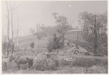
Photograph, The Busy Corner, 1907
... mount dandenong north... jeeves barbers road beulah tea rooms post office mount dandenong ...View of Jeeves Saddle in 1907 showing everyday life and including important people and businesses from early settlement - Dodd's grocery and meat cutting carts; Beulah tea Rooms/Post Office; Mrs Hand, Fred Jeeves, Theo Hand.This photograph has a detailed inscription on the back handwritten by John Lundy-Clarke in 1974.“Jeeves Saddle” in 1907. Isaac Jeeves special strip of land Crown Allotment “C” 7 chains wide, lay between the sledge load of pea stalks and the far end of the verandah on Mrs Hand’s “Beulah Tea Rooms” which soon afterwards became the Mt Dandenong North Post Office. The coach road came up from the right behind the tall stump. The big woman in black was Mrs Hand. The wagon at the shop was Dodd’s grocery cart. The nearer wagon was the first coach on the mountain which had belonged to Briarty. The small cart was Dodd’s meat cutting cart. The elm trees are in the centre of the picture and above them is Price’s sign advertising their shop and newsagency. The big house is “Mountjoy” burnt 1975. Walker’s house is among the big trees left centre. Boy at horse’s head is Fred Jeeves. Boy on sledge is Theo Hand. The horse is “Blossom”. Barbers Road goes to the left from behind the elm trees.jeeves, theo hand, fred jeeves, isaac jeeves, barbers road, beulah tea rooms, post office, mount dandenong north, mt dandenong north, kalorama, coach, mountjoy -
 Mt Dandenong & District Historical Society Inc.
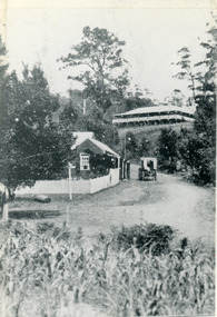
Photograph, The Gap at Kalorama 1913, 1913
... Dandenong North Post Office. Jeeves coach..... ‘Mountjoy’ guest house. Mount Dandenong North Post Office. Jeeves ...1913 scene looking up to Mountjoy Guest House at the Kalorama Gap (FiveWays). Post Office and tea rooms with white picket fence. Jeeves Coach on the road. This photograph has a detailed inscription on the back handwritten by John Lundy-Clarke in 1974. The Gap Kalorama 1913. ‘Mountjoy’ guest house. Mount Dandenong North Post Office. Jeeves coach.fiveways, mountjoy, post office, mt dandenong north, the gap, jeeves, coach -
 Churchill Island Heritage Farm
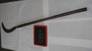
Fern hook
... with every cut!” churchill island fern hook olinda mount dandenong ...Donated by Wilfred Dungan on behalf of the Dungan family Collection originally used on the property of the late Dr Rae Dungan in Falls Creek Rd Olinda, purchased in the late 1930s from Olinda pioneers Harry and Minnie Holden. Also on the property of late May Farndon of Farndon’s and Falls Rd Mt Dandenong – aunt of Dr Rae William Dungan and also an early pioneer. Family holidays and weekends involved use of these sorts of farm implements plus working with horses. Post-war, the Olinda hand tools and machinery moved to the Shady Creek, Nilma North area where bush, pasture and cows had replaced the Olinda property. Wilfred well remembers being on one end of the crosscut saws cutting fence posts, logs and timber under “the tireless and vocal instruction” of a red headed local Darnum Rd legend called Harry Collyer. “He drove an old Rugby car and nearly pulled me through the logs with every cut!” Curved blade, painted black. Wooden limb handle, varnished, some white paint spots. Nail into handle in blade holder sleeve. Slight bulge in handle near blade holderchurchill island, fern hook, olinda, mount dandenong, nilma north -
 Mt Dandenong & District Historical Society Inc.
Photograph, Post Office and 'Mountjoy', Mt. Dandenong North, 1913
... of the verandah was the Mount Dandenong North Post Office. The large house... of the verandah was the Mount Dandenong North Post Office. The large house ...Rose Series post card #182Copy of Rose Series postcard #182 showing Kalorama Gap in 1913. Haystacks in foreground with Mountjoy Guest House and Beulah Tea Rooms/Mt Dandenong North Post Office in centre. This photograph has a detailed inscription on the back handwritten by John Lundy-Clarke in 1974.Kalorama Gap in 1913 The elm trees are in the centre of the picture. One of these is really two as two suckers of the further tree were twisted together by Fred Jeeves in 1898 and grew as one tree. The other was planted in 1880. The shop is the shop of Mrs Eliza Hand and daughter Florence. The closed in far end of the verandah was the Mount Dandenong North Post Office. The large house is “Mountjoy” owned and run by the Jeeves Family from 1908 till 1943. It was built in 1905 by the Paynters who sold to Ellis Jeeves in 1908.He moved his line of coaches from “Kalorama” his old homestead and housed the horses in a line of stables behind “Mountjoy”. Price’s house, which contained their shop, the first one on the mountain, opened 1906, can be seen faintly behind the pine tree opposite the bend in the road, which was the main road then and now is Ridge Road. The Price’s house just shows in two tiny pieces, one on each side of the pine tree half way up. The house to the right of and high up the pine tree is Walker’s cottage which exists today opposite Jack Kidd’s home at the far edge of Lt 2 Village Settlement and was between Main Road and Barbers Road which runs down the left behind the elms. Walker’s homestead can be seen near left edge of picture 2/3 way up. The roof of the Methodist Church shows among trees left of picture. This, like Mrs Hand’s shop was built on portions separated from Isaac Jeeves’ Selection “C” known as Jeeves Saddle. kalorama gap, five ways, mountjoy, john lundy-clarke, beulah tea rooms, post office, fred jeeves, paynter, jeeves, frederick jeeves, price, walker, jack kidd -
 Mt Dandenong & District Historical Society Inc.
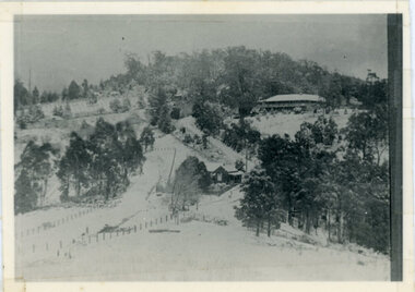
Photograph, Kalorama Gap Under Snow 1921, 1921
... Dandenong North Post Office. The old Main Road runs up the centre..., which was the Mount Dandenong North Post Office. The old Main ...View of Kalorama Gap under snow taken in 1921. Mountjoy Guest House is at top right and Beulah Tea Rooms is in the centre. This photograph has a detailed inscription on the back handwritten by John Lundy-Clarke in 1974.Kalorama Gap under snow 1921 The leafless elm trees are low in the centre and the dual nature of the nearer one can be clearly seen, two small suckers of the older farther tree being twisted together in 1898 by Fred Jeeves. The older tree was planted 1880. Mrs Hands shop can be clearly seen, which was the Mount Dandenong North Post Office. The old Main Road runs up the centre of the picture and turns to the right and disappears behind “Mountjoy” the big guest house built by Paynters in 1905 and sold to Ellis Jeeves 1908, whose family ran it till 1943. At the bend of the road behind the big pine tree and the dark blackwood can be seen faintly the gable of Price’s house that contained the first shop on the mount. Above it is H Walker’s cottage on Ridge Road that still exists, his homestead is on the left of the picture on the same level. Below this house and to the left can be seen Ted Prices hay and corn store. The present estate agency lies between these two buildings, on the road which had recently been built. This can be seen winding from the lower left corner of picture to the left of the elms. The CRB had recently fenced the road and this is clearly seen as it circles behind trees in the left centre. Barber’s Road crosses CRB Road to the left of the dray under the leafless elm and the Coach Road dives down to the right just behind the pair of blackwoods to right of the elms. The picture was taken from just above the boundary of Isaac Jeeves’s selection Crown Allotment “C” (Jeeves Saddle) which stretched across the Gap to the other side of Mrs Hand’s shop, monopolising the gap from 1871 to 1879. Price’s house remains partly as the small house – “Mirra Laken”. kalorama gap, fiveways, post office, mountjoy, guest house, snow -
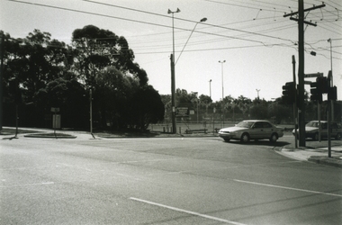
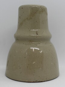 Ringwood and District Historical Society
Ceramic - Insulators, Insulator factory in East Ringwood, Two ceramic insulators made in East Ringwood from local clay - c.1900, c. 1900
The insulator factory and ovens were located on the SW corner of Velma Grove and Mount Dandenong Road approx. Quarrying for clay was done in the nearby area. Refer photographs of the factory.Two ceramic insulators made in East Ringwood from local clay. Colour grey. Conical with indentation in middle for wires. There is a second 'skirt' inside to enhance insulating performance. The inner hole is threaded. -
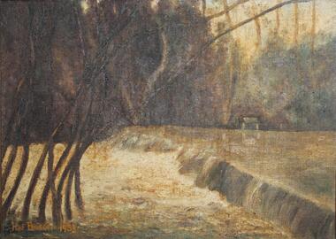 Ringwood and District Historical Society
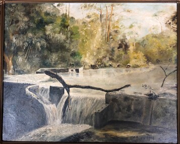
Painting, "Busch's Weir" - Oil on canvas by Hermann Otto ("Hof") Busch (1880-1960), 1953
In the 1930s, Hermann Busch constructed a concrete wall across Dandenong Creek, forming "Busch's Weir" on his Bayswater property, "Waldheim". The weir wall was demolished in the 1960s.One of two paintings of weir across Dandenong Creek, mounted in beveled edge wooden frame with ornate corner moldings. (See Reg #4856B for other of two paintings in the pair)Hof Busch 1953 -
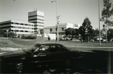 Ringwood and District Historical Society
Photograph-B&W, Joan Walker, East Ringwood 2000-Maroondah Hospital in Mount Dandenong Road, 2000
East Ringwood 2000-Maroondah Hospital in Mount Dandenong Road- B&W Photo from Album 6501 -
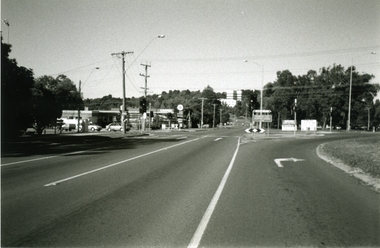 Ringwood and District Historical Society
Photograph-B&W, Joan Walker, East Ringwood 2000-Taken at the cnr: Mount Dandenong Road and Dublin Road (Maroondah Hospital in the distance), 2000
East Ringwood 2000-Taken at the cnr: Mount Dandenong Road and Dublin Road (Maroondah Hospital in the distance.- B&W Photo from Album 6501 -
 Ringwood and District Historical Society
Photograph-B&W, Joan Walker, East Ringwood 2000-East Ringwood Tennis Courts and the Cnr: Mount Dandenong & Dublin Roads, 2000
East Ringwood 2000-East Ringwood Tennis Courts and the Cnr: Mount Dandenong & Dublin Roads.- B&W Photo from Album 6501 -
 Ringwood and District Historical Society
Photograph-B&W, Joan Walker, East Ringwood 2000-Maroondab Club in Mount Dandenong Road Ringwood East, 2000
East Ringwood 2000-Maroondab Club in Mount Dandenong Road Ringwood East- B&W Photo from Album 6501 -
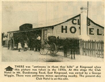 Ringwood and District Historical Society
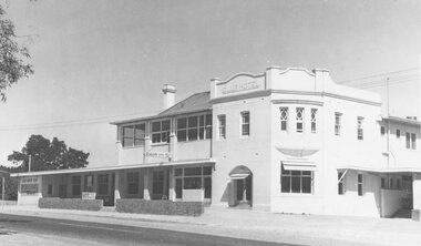
Photograph - Newspaper Clipping, Early View of Club Hotel, Ringwood East
... of Mount Dandenong Road. It was destroyed by fire in 1890 prior... of Mount Dandenong Road. It was destroyed by fire in 1890 prior ...The newspaper clipping caption is incorrect. The Club Hotel featured in the article was located on the north side of Mount Dandenong Road. It was destroyed by fire in 1890 prior to re-opening later on the south side where it operated until sale and demolition in 2020 to make way for a retirement village. (See PDF attached - "SS0067 Vic Collections 3754b - Club Hotel Fire 1890").Early View of Club Hotel, Ringwood East. Weatherboard with iron roof. Single chimney on one end. Picket fence on RHS. Two horse-drawn vehicles standing out front including three adults and two children. Source/date of newspaper unknown. Later newspaper item also attached reporting hotel being destroyed by fire in 1890.Caption: There was 'antimony in them thar hills' at Ringwood when this picture was taken in the 1890s. At that time the Club Hotel in Mt Dandenong Road, East Ringwood was owned by a George Wiggin. There were antimony mines operating nearby. The present-day Club Hotel is on this site. -
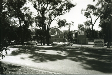
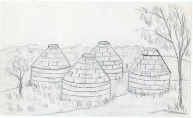 Ringwood and District Historical Society
Work on paper - Pencil sketch, Artist unknown, initials D.M, Sketch of pottery kilns at East Ringwood, corner of Velma Grove and Mount Dandenong Road (Oxford Road). Kilns shut down in 1926, c.1926
Sketch of the four pottery kilns at East Ringwood, corner of Velma Grove and Mount Dandenong Road (Oxford Road). The kilns shut down in 1926. Judging by the handwriting, the artist and author appears to be John Rodaughan, East Ringwood historian, whose other works include history on Burnt Bridge Hotel and other parts of East Ringwood. The back of the sketch includes a rough hand-drawn map, that appears to be of the insulator works area, between Mt Dandenong Road and Evon Avenue. The timeline includes generic milestones in blue ink and those associated with Ringwood in red writing.Kilns; D.M. -
 Ringwood and District Historical Society
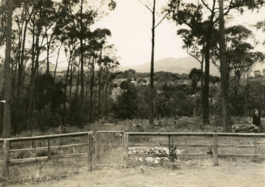
Photograph, Ringwood: Wooden fence and cyclone gate overlooking Mount Dandenong, Kilsyth and Heathmont, taken from Bedford Road, looking South. (undated), circa 1920
A photograph of a wooden fence with a cyclone gate overlooking Mount Dandenong, Kilsyth and Heathmont. Taken from Bedford Road, looking south. Donated by Mrs Purser and has printer's marks that suggest that the photograph was printed in a newspaper.View over Ringwood -
 Ringwood and District Historical Society
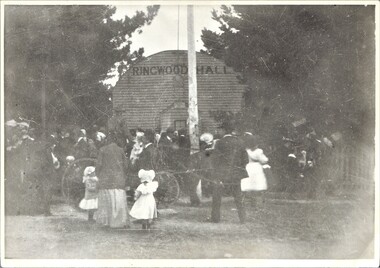
Photograph, Ringwood Hall, Mount Dandenong Road, Ringwood - circa 1900, Circa 1900
Ringwood Hall was located near the Club Hotel in Mount Dandenong Road prior to construction of Mechanics Institute/Town Hall in Maroondah Highway in 1909.Black & white photo of crowd gathered at original Ringwood Hall, Mount Dandenong Road, Ringwood. "Old Ringwood Hall nr. Club Hotel, later burnt down approx 1909". "Old Ringwood Hall prior to Mech Inst of 1909". -
 Ringwood and District Historical Society
Painting, "Busch's Weir" - Oil on canvas by Hermann Otto ("Hof") Busch (1880-1960), 1953
In the 1930s, Hermann Busch constructed a concrete wall across Dandenong Creek, forming "Busch's Weir" on his Bayswater property, "Waldheim". The weir wall was demolished in the 1960s.One of two paintings of weir across Dandenong Creek, mounted in beveled edge wooden frame with ornate corner moldings. (See Reg #4856 for other of two paintings in the pair)Hof Busch 1953 -
 Ringwood and District Historical Society
Legal record - Fire Insurance document (C.E.Carter), Fire Insurance - Commercial Union Assurance Co Ltd for Charles W Bruce, 1943
Standard form of Fire Insurance Policy issued by Commercial Union Assurance Co LtdPolicy issued to Charles W. Bruce, for dwelling in Mount Dandenong Road, Ringwood. -
 Ringwood and District Historical Society
Photograph, Sandy Creek Bridge, Maroondah Hwy, Ringwood - 1900, prior to construction of Ringwood Lake - antimony mine in distance
Written on photograph, "New Sandy Creek Bridge" and typed below photograph, "Maroondah Highway Ringwood looking east. To right of bridge (became) Ringwood Lake. Mount Dandenong Road turnoff to right at top of rise with antimony mine in background - 1900". -
 Ringwood and District Historical Society
Photograph, "Healesville Road, Ringwood" postcard featuring westward view along Whitehorse Road towards Mount Dandenong Road, Ringwood - c.1920
Postcard labelled Healesville Road, Ringwood with additional copies including descriptions "Looking down a dry Maroondah Highway from outside (eventual) Civic Centre site towards Mt. Dandenong corner", "Later Whitehorse Road / Maroondah Highway C1920 approaching Ringwood from east." -
 Ringwood and District Historical Society
Photograph, Club Hotel, Mount Dandenong Road, Ringwood East - 1960
Written on back of photographs, "Club Hotel Ringwood East. 1960." "Club Hotel, Mt. Dande Rd. 1960" and "1960 Club Hotel" -
 Ringwood and District Historical Society
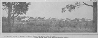
Photograph, Image used for land sale promotion of Pratt's Junction Estate opposite Mount Dandenong Road, Ringwood - 24/11/1923
Catalogue card reads, "Pratt's Junction Estate - 24/11/1923, 86 lots". -
 Ringwood and District Historical Society
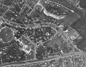
Photograph, Aerial view showing East Ringwood oval, Mount Dandenong Road, and Civic Centre, Braeside Avenue/Maroondah Hwy, c.1970
Aerial view showing East Ringwood oval, Mount Dandenong Road, and Civic Centre, Braeside Avenue/Maroondah Hwy, c.1970. -
 Ringwood and District Historical Society
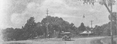
Photograph, Whitehorse Road and Mount Dandenong Road, including early electric installation of street lighting. (Undated)
Written on back of photograph, "Whitehorse Road and Mount Dandenong Road". Catalogue card reads, "Early electric installation of street lighting". -
 Ringwood and District Historical Society
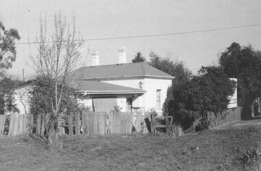
Photograph, Ringwood's first Police Station, 32 Mount Dandenong Road. (note room at left)
Written on back of photograph, "32 Mount Dandenong Road. Ringwood's first Police Station (note room at left). -
 Ringwood and District Historical Society
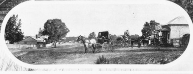
Photograph, Mount Dandenong Road, Ringwood. Blood's store on right, Club Hotel behind tree, Cornell's store on left. c.1900-1910
... Road Ringwood North melbourne Photograph Mount Dandenong Road ...Written on backing sheet, "Blood's store on right, Club Hotel behind tree, Cornell's store on left". -
 Ringwood and District Historical Society
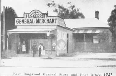
Photograph, Skerrett's Store and Post Office, 1923. Diagonally opposite from Club Hotel in Mount Dandenong Road
Catalogue card reads, "Skerrett's Store and Post Office, 1923. Diagonally opposite from Club Hotel." -
 Ringwood and District Historical Society
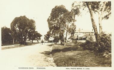
Photograph, Mount Dandenong Road, Ringwood East, c.1925. Club Hotel on right, Skerrett's Store on left
... Road Ringwood North melbourne Photograph Mount Dandenong Road ...Typed below photograph, "Mt. Dandenong Rd., Ringwood East, c.1925" Written on backing sheet of an enlargement, "Mt. Dand. Rd., Skerrett's Store (Darsons) on left. c1925". -
 Ringwood and District Historical Society
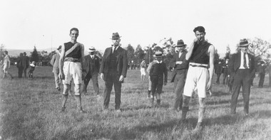
Photograph, Footballers at Mount Dandenong Road Recreation Ground oval circa 1914
Footballers at Mount Dandenong Road Recreation Ground oval circa 1914. Man in centre with hat and pipe possibly A. J. (Jun) Sugden, headmaster of Wantirna School, and Bob Skerrett on right hand side with hat.Catalogue card reads, "Possible? Man in centre with hat and pipe A. J. (Jun) Sugden, headmaster of Wantirna School. RHS with hat (front) ? Bob Skerrett?" -
 Ringwood and District Historical Society
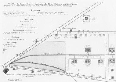
Photograph, Land sale brochure map of Ringwood's early main central area around Mount Dandenong Road - c.1880s
Catalogue card reads, 'Map of Ringwood East'. -
 Ringwood and District Historical Society
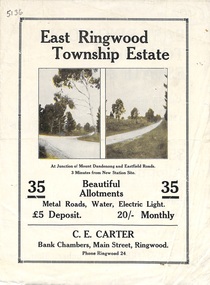
Flyer, Subdivisional Land Sale Brochure, East Ringwood Township Estate, Vic. - 1923
Bi-folded double sided land subdivision sale advertisement with location map and summary of local facilities and services. Includes two additional images of allotment plan with subsequent handwritten notations.Subdivision includes Mount Dandenong Road, Grey Street, and Eastfield Road. Agent - C.E. Carter, Bank Chambers, Main Street, Ringwood. Phone Ringwood 24.